HEC-RAS 2D vs 1D Model Selection for FEMA Submittals
Choosing 1D or 2D HEC-RAS depends on site geometry, not software preference.
Choosing the right hydraulic model for a FEMA submittal, whether 1D, 2D, or coupled, is not a question of preferring newer software over older. It is a function of flow geometry, terrain quality, floodway requirements, and FEMA's own acceptance criteria, and engineers who understand those drivers select the correct approach before building a mesh rather than reworking deliverables after a review comment. The distinction carries real financial weight: the wrong choice surfaces during FEMA review, when rework costs far more than a careful upfront decision would have.
Why FEMA submittals create a model selection problem worth solving
FEMA cannot accept Flood Insurance Studies or map revision requests performed with numerical models that are not on its list of nationally or locally accepted models, per FEMA Guidance Document 98. HEC-RAS sits at the center of this constraint because it is the dominant accepted hydraulic model for NFIP flood studies. What remains open is the dimensionality question, and that decision is far from cosmetic. It determines whether the submittal passes review, whether floodway analysis can be performed at all, and whether the delivered water-surface profiles match the physical reality of the site.
The cost structure makes the decision consequential before any model is built. A project that selects a 2D approach when the reach behaves as a confined 1D channel will produce results that reviewers can identify as inconsistent with site conditions. Firms that embed their own submittal history and hydraulic standards into a repeatable intake process, the way desktop workflow tools like Gradon do for engineering teams, can front-load that decision logic so the right modeling approach is selected before any mesh is built, not after review.
What FEMA's acceptance framework actually requires before modeling begins
FEMA separates numerical models into nationally accepted and locally accepted lists under 44 CFR Paragraph 65.6(a)(6). Only models on those lists can support Flood Insurance Study submittals and map revisions. The lists are organized by the area of responsibility of the certifying agency, with four nationally accepted model types: coastal, hydrologic, hydraulic, and statistical. They are updated periodically, and engineers should contact the FEMA Mapping and Insurance eXchange for the current versions. Every submittal has to clear this floor before modeling begins.
Before you choose a dimensionality, you must also make a site-level determination. Check the effective Flood Insurance Rate Map for the project area first. If the project intersects the regulatory floodplain, meaning Zones A, AE, AO, AH, V, or VE, a review comparing current and post-project conditions may be needed, per FEMA Region 6 HOW2 guidance. That determination sets the deliverable scope, which in turn shapes what the model must produce.
What the framework does not do is specify which HEC-RAS dimensionality to use. FEMA's rules require only that the chosen model be accepted, documented, and capable of producing the specific outputs the deliverable demands: base flood elevations, floodway delineation, or no-rise certification. The site conditions and the deliverable type set the ceiling, and that is where the real decision begins.
The geometry and terrain conditions that make 1D the appropriate choice
One-dimensional modeling remains the correct choice when flow is predominantly unidirectional along a well-defined channel with minimal lateral expansion. The practical advantage compounds across the project schedule: 1D models compute faster and allow extraction of a wider range of hydraulic outputs per run, including velocity, Froude number, shear stress, normal depth, and critical depth. Run-time constraints are a legitimate engineering reason to choose the simpler model.
Terrain quality is the second major driver. A 2D mesh derives its accuracy directly from the underlying digital elevation model, which means problem with low-resolution or incomplete terrain data are not solved by forcing a 2D approach. A 1D cross-section approach, by contrast, is less sensitive to DEM gaps and can be built defensibly from surveyed sections.
The structural inventory matters as well. In one documented case, a watershed with numerous bridges along a primary river was studied in parallel with a 2D model, and the 1D model produced more accurate water levels against calibration data. If bridge modeling fidelity is what decides the outcome, 1D is the defensible choice. Once workflow automation has learned a firm's past 1D projects and standards, junior engineers can use those outputs on similar geometries instead of rebuilding the decision tree for each new reach. One additional operational factor favors 1D in large drainage areas. That integration issue alone can consume the budget that a more sophisticated model was supposed to save.
The site conditions where 2D modeling produces results 1D structurally cannot
Two-dimensional modeling earns its selection not because it is newer but because certain physical conditions cannot be represented in one dimension at all. The defining case is flow that is expected to spill into and travel across the floodplain in directions that cannot be predetermined. Alluvial fans, meanders, estuaries, and floodplains with significant lateral spreading all fall into this category. Each of those behaviors affects the base flood elevation at any given point, which means a project in a complex floodplain carries structural error if it is forced through a 1D model.
Dam breach analysis is the clearest affirmative case for 2D. California's inundation mapping regulations explicitly recommend 2D in areas of lateral spreading, which puts the choice on a regulatory footing for that class of work. The second strong argument is the AO and AH zone capability. If you put rainfall on the grid as a boundary condition, 2D modeling can simulate ponding areas and shallow overland flows outside the stream channel, which 1D cannot. Where a site includes those zone types, the model must represent them, and 2D is the only available structure for doing so.
How the 2D encroachment tool changed the floodway analysis calculus
Until recently, a pure 2D model stayed out of many FEMA submittals no matter what the site conditions were. When HEC-RAS 2D was introduced in the 2016 release, it lacked the ability to perform floodway analysis, which is a requirement for producing a regulatory Flood Insurance Rate Map. That gap effectively forced engineers back to 1D for any project requiring a floodway. HEC-RAS version 6.4, released June 2023, closed the gap by incorporating an encroachment tool that enables floodway delineation in 2D modeling. For the first time, a 2D model could produce the floodway output that a FIRM submittal requires.
The practical consequence is significant. If you have the encroachment tool, 2D models can now produce BFE contour lines continuously across a watershed and display them directly in the FIRM 2D format, without the traditional cross-section profiles and floodway data tables of a 1D Flood Insurance Study. The implication for model selection is concrete: the question is no longer whether 2D can produce a FIRM-ready floodway, since it can, but whether the site geometry, terrain quality, and project scope make 2D the better approach for that particular submittal. It does not make 1D obsolete.
When coupled 1D/2D is the technically correct answer, and what it costs to run one
Coupled 1D/2D modeling is neither a compromise nor a default. It is the appropriate choice when a single study area demands 1D features, such as detailed bridge modeling, structured channel conveyance, and HEC-HMS inflow integration, while simultaneously requiring 2D domain behavior across a floodplain. The documented case of three parallel rivers bisected by a railroad illustrates when this configuration becomes unavoidable. At first they built three separate 1D models, and the system failed to represent overtopping flows that crossed watershed boundaries during an extreme event. Only a coupled model could simulate that behavior correctly.
The results of coupling are not merely cosmetic. Research comparing coupled 1D/2D and pure 2D approaches on the Dinsiz Stream Basin found that maximum water levels in the coupled models were consistently higher than in the 2D-only models across multiple return periods, per Spor et al. (2025). That difference has direct implications for base flood elevations and floodway width, which means a project in a coupled-appropriate setting that chooses pure 2D may understate its flood elevations.
Coupled models cost a lot to run, and you should enter the configuration with your eyes open. The 1D/2D interface can be numerically unstable, and it needs careful configuration, including practices that are not always in the manual, such as zero-height weir settings. Coupled modeling is the right answer in specific conditions, but it carries a real setup and stability burden that must be weighed against the physical requirements of the site.
A working decision framework: matching model type to project conditions before setup begins
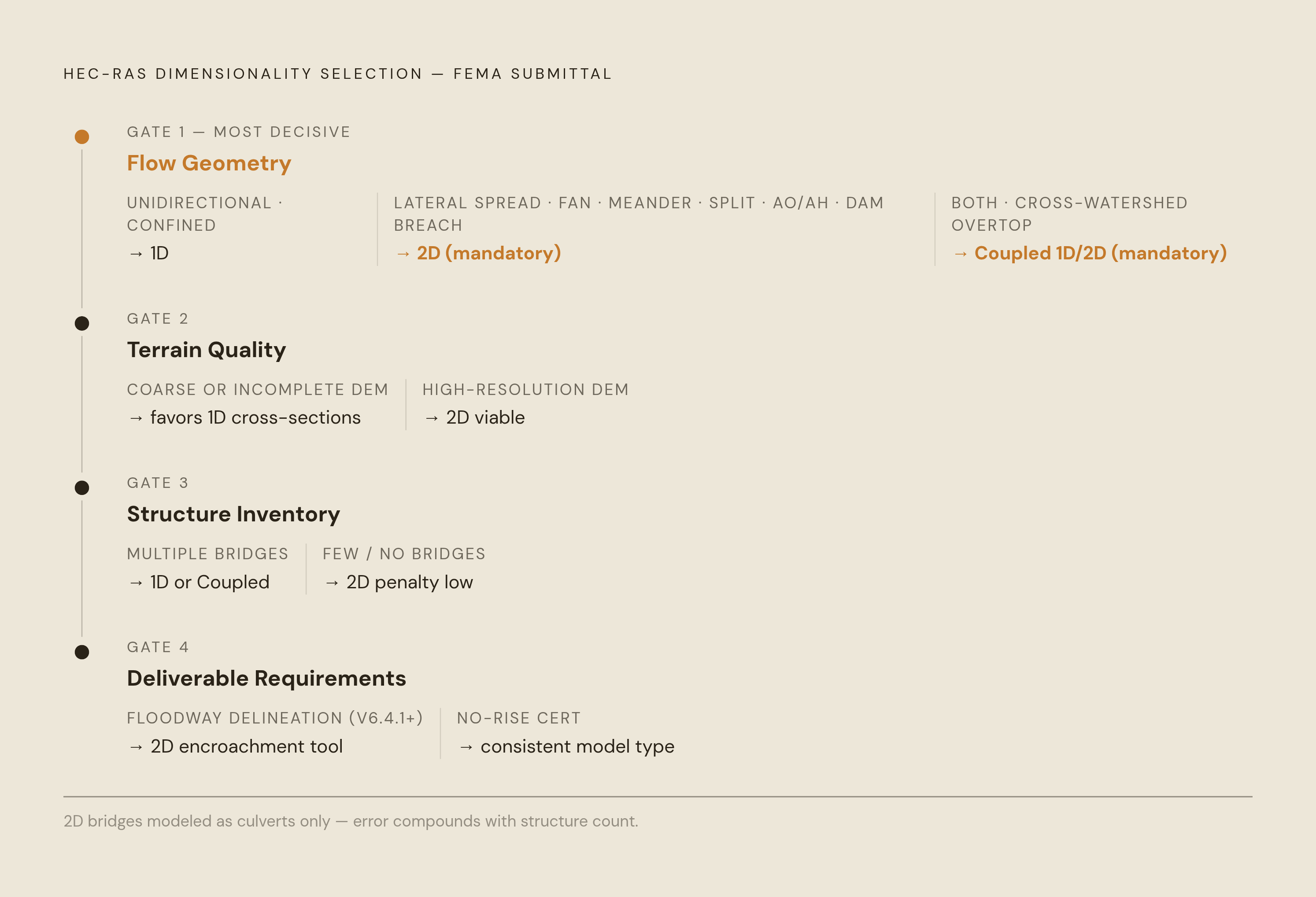
The model choice is driven by four factors in sequence: flow geometry, terrain quality, structure inventory, and deliverable requirements. Working through them in order prevents a premature commitment to any one dimensionality.
- Flow geometry first. Predominantly unidirectional flow in a confined channel with minimal lateral spreading points to 1D as appropriate and often preferable. Lateral spreading, an alluvial fan, meanders, split flow, AO/AH zone shallow flooding, or dam breach conditions make 2D structurally necessary. When both conditions are present in the same study area, or when cross-watershed overtopping is possible, coupled 1D/2D is the correct choice.
You cannot trust 2D results on coarse or incomplete terrain data, but 1D's cross-section approach is less sensitive to DEM gaps.
- Structure inventory third. Multiple bridges in the study reach favor 1D or coupled, since 2D can represent bridges only as culverts and the error compounds across a multi-bridge reach. Few or no bridges, with hydraulic structures excluded or minor, lowers the 2D penalty.
- Deliverable requirements fourth. When floodway delineation is required, the 2D encroachment tool is now available in version 6.4.1 and later, while 1D encroachment analysis remains established practice. For FIRM format output, 2D contour-based FIRM 2D is now a viable output alongside traditional 1D cross-section profiles. No-rise certification for floodway work requires modeling existing and proposed conditions in the same model type, and consistency between conditions matters as much as the choice of dimensionality.
One additional point deserves emphasis. FEMA's documented response to the alluvial fan case study, in which a 2D model was used to develop cross-section orientation for a 1D regulatory model, confirms that using 2D to inform 1D is an accepted best practice for complex sites, not a workaround. The modeling approaches are not competitors in every project. Sometimes the right answer is to use one to shape the other.
Where HEC-RAS production work actually stands right now, and what engineers should track
Engineers applying this decision framework need to know which version of HEC-RAS to run production work in and what is coming. HEC-RAS 6.x is the correct version for all deliverable-quality FEMA work. Version 6.4.1 introduced the 2D encroachment tool that makes full FIRM 2D submittals possible, and subsequent 6.x releases have continued to refine 2D and sediment transport capabilities. HEC-RAS 2025 entered public beta in March 2026 with Beta 1 released March 30, 2026, as a ground-up rewrite involving a different codebase, a different solver architecture, and a different file format. USACE explicitly states that it is not recommended for production engineering studies in its current beta state, and models cannot be moved directly between 6.x and 2025 without substantial rework. The practical guidance is simple: production work stays on 6.x, and firms should track 2025 without adopting it.
If you run Base Level Engineering studies, FEMA gives you the models through the estBFE Viewer. The 1D files sit by stream name, and you can reach the 2D files through a 2D Model Inventory in the RAS_Submittal folder, per FEMA Region 6 HOW2 guidance. That access shortens the setup phase for projects that build on BLE data.
The practical bottleneck in most FEMA submittal workflows is not the modeling decision itself. It is the time required to set up, run, and QA the model, reconcile it with the drawings, and produce the required deliverable set: drainage reports, FIS documentation, floodway data tables, and elevation certificate support materials. A firm that handles that bottleneck well can produce more submittals with the same staff. Gradon is built specifically for that class of AEC work, running HEC-RAS hydraulic analysis, drainage reports, and SWPPP deliverables inside the tools firms already use, including Civil 3D, HEC-RAS, and Bluebeam, while learning each firm's own standards so the output stays consistent with prior submittals. A licensed professional reviews every deliverable before it leaves the firm. For small and mid-size civil and water-resources firms that bill FEMA-related work regularly, the compounding value is in throughput: the same team that selects the correct model upfront and runs production efficiently can take on more projects without adding headcount.